
© Robert Reynolds

Not subway-related, but also web-published (January 2008) by Robert Reynolds:
A Primer on Civil Life
Short Questions and Responses
for Young People to Ponder
and to Discuss with Friends
The Subway Page

Links to World Subway
and Other Transportation Information Resources
- Use the menu below to access material other than subway maps.
- On this page, the official system map appears first (in principle) when it is available, but no representation is made as to current status for any of these maps.
- This page has no official status with respect to any operating system.
- Both archival maps and contemporary maps are included.

image: Stockholm Local Transport Authority
Menu
(each bullet is a distinct page)
City subway maps
(select a city's initial letter to minimize the need to scroll)
[A], [B], [C], [D], [E], [F], [G], [H], [I], [K], [L], [M], [N], [O], [P], [R], [S], [T], [U], [V], [W], [Y], [Z]
Map collections of others -- subway (principally) and other transit Whimsical uses of the subway map theme Subway route navigation aids Scanned subway-related items from my own collection and those of others
City and area transit guides Metro area tram, bus, light rail, and rail system maps only
Individual, institutional, and corporate transit pages General transit resources
Books, bibliographies, special items of interest Images relating to subways and urban transit Museums, historical displays, and clubs
Photo by Robert Reynolds
City subway maps
Tyne and Wear Metro Logo
(thanks to Roger Fern for identification)
[B], [C], [D], [E], [F], [G], [H], [I], [K], [L], [M], [N], [O], [P], [R], [S], [T], [U], [V], [W], [Y], [Z]
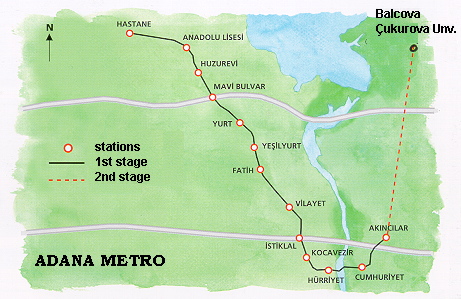
Users of the unauthorized partially copied site might enjoy the full source site at The Subway Page Adana Kerem F. Solyu has advised that the university indicated on the map should be Balcali, not Balcova
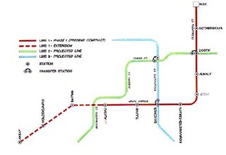
Almaty (essentially illegible map 1996 from SNC-Lavalin; under suspended(?) construction)
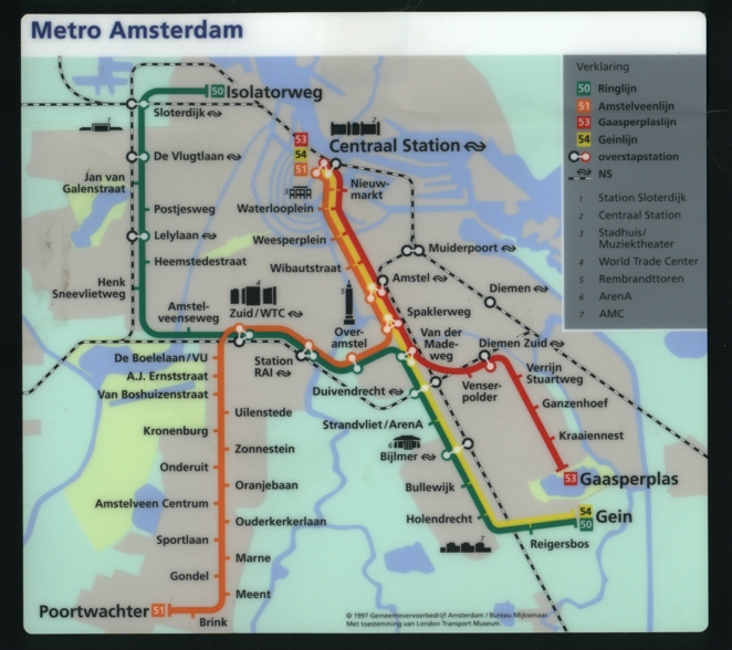
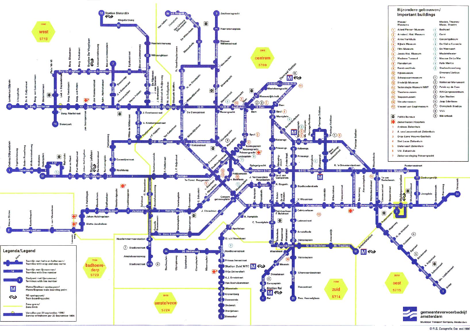
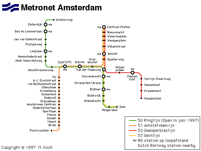
Amsterdam (official GVB site for all public transport; thanks to Robert van Deijck for update applied 2009.08) Amsterdam (map by Amsterdam Tips; thanks to Luc Bennett for site information [7.10]) Amsterdam (Metro system including parts under construction: Noord-Zuidlijn and Ijlijn; completion in 2008; thanks to Jeroen Kemperman for map and information; Robert van Deijck now advises completion is planned for 2015 (as of 12/08)) Amsterdam (map provided by Amsterdam.info, which also provides general transit and other information; thanks to Ondrej Pastirik) Amsterdam (smaller version;plan used in metro trains; scan a generous gift of Wilko Wieffering, who notes that although the De Vlugtlaan metro station is active, the corresponding train station is not) Amsterdam (Robert Schwandl original; UrbanRail.Net) Amsterdam (1996 archive version; thanks to Peter Jager) Amsterdam (map created and provided by M. E. Koch; thanks to John Kerr for pointing out the errors: the legend on this map should say "53 Gaasperplaslijn and 54 Geinlijn) Amsterdam (map by Osamu Abe 2001.2)
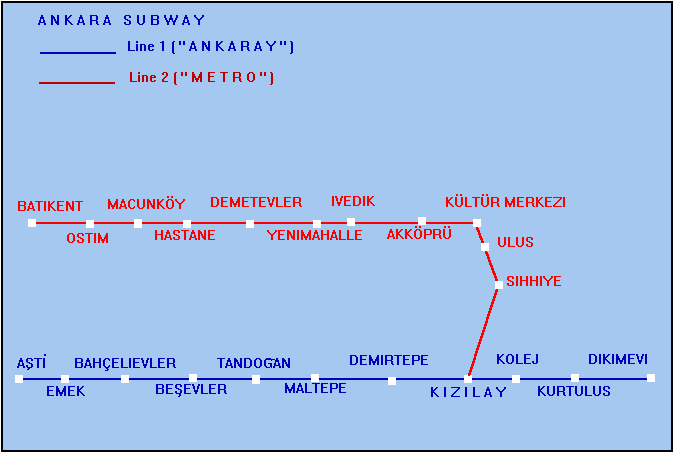
Ankara (Railway Technology - EGO; thanks to Dan Weissmann; [4.9.09]) Ankara (EGO-1997) Ankara (two lines ('ANKARAY' and 'METRO'); both lines underground (Ankaray has only one street level station: its name: 'Emek'). ANKARAY opened a few months ago; METRO almost completed, opening hopefully this year." -- 9 Jun 97) Ankara (map by Osamu Abe 2001.10)
Antwerp (map thanks to Patrick van Dijk; his comments follow)
The filled squares are stations in use, the partly filled squares are inoperative stations.
You really have to compare this map to a normal map of Antwerp for better insight of the locations (Stations 'Groenplaats' and 'Meir' are located in the very heart of the city, while 'Diamant' is closest to the railway station).
Unfinished station -> Location (street name):
Carnot -> Carnotstraat
St.-Willibrordus -> Kerkstraat
Stuivenberg -> Pothoekstraat
Drink -> Turnhoutse baan
Zegel -> Turnhoutse baan
Foorplein -> Turnhoutse baan
Collegelaan -> Stenen brug
Morckhoven -> Stenen brug / Herentalse baan
Antwerp (map by Osamu Abe 2001.03; thanks to Anthony Perrotta for link correction)
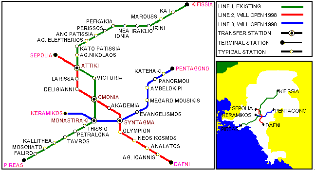
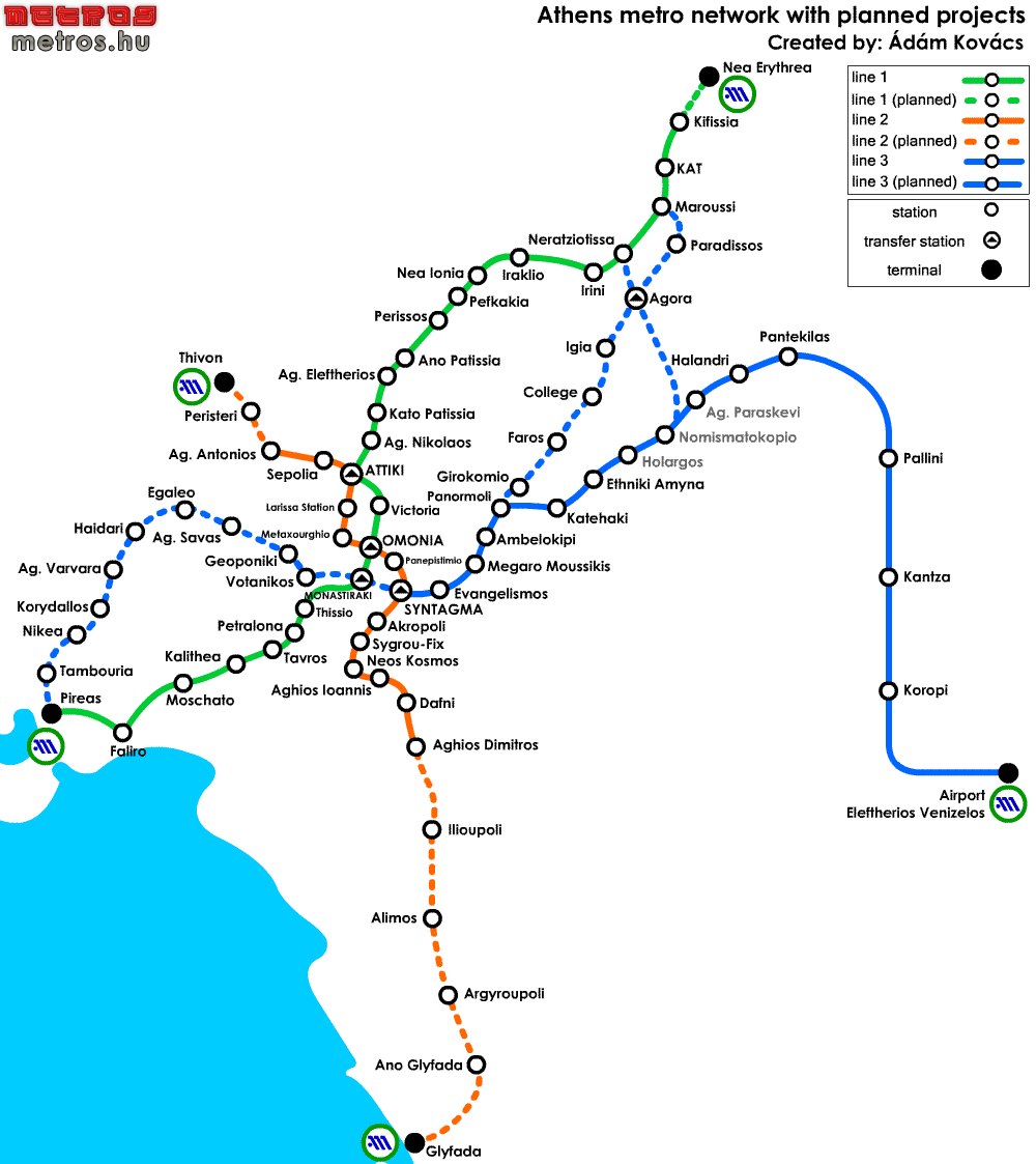
Athens (official Attiko Metro) Athens (map downloaded from Dmitry Zinoviev's former Metasubway page) Athens (Robert Schwandl original; UrbanRail.Net) Athens (original map by Kovács Ádám; updated 12/05)
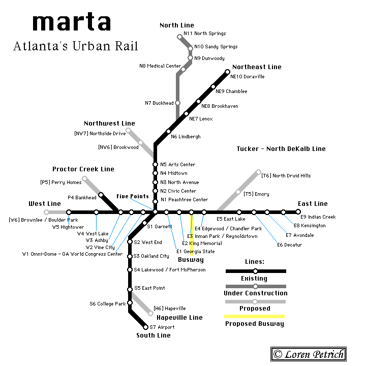
Atlanta (official MARTA; thanks to Gunter Sharp for update information here and elsewhere in the Atlanta section); a light rail loop is also proposed (thanks to Grant Gandy for the link) Atlanta (Loren Petrich) Atlanta (map by Osamu Abe 2001.02)
[A], [C], [D], [E], [F], [G], [H], [I], [K], [L], [M], [N], [O], [P], [R], [S], [T], [U], [V], [W], [Y], [Z]
Baku (Metametro of Vadim Dzygoon; map by Dmitry Zinoviev 2000) Baku (map by Osamu Abe 2004.02)
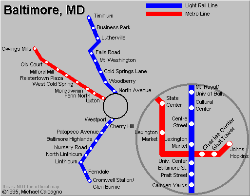
Baltimore (official Maryland Mass Transit Association metro page; thanks to Rick Pike for update information) Baltimore (downloaded map by Michael Calcagno) Baltimore (map by Osamu Abe 2004.05)
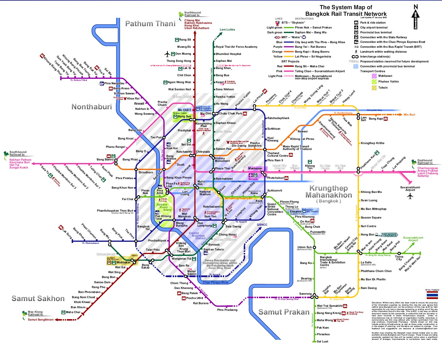
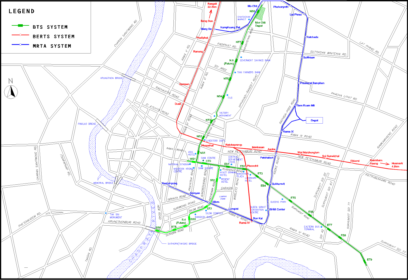
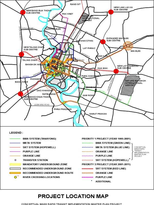
Bangkok; see grey Time and Fare Journey map on right (official Bangkok Metro Company Limited; thanks to Thanus Ballapapinan, Chief Controller, and to Ron Morris) Bangkok pdf download of the system; large map by Chatchawal Phansopa Bangkok pdf download of the Transport System Master Plan Version 7.5; large map by Chatchawal Phansopa Bangkok (Full Transit System Master Plan; thanks to "pnitaya") Bangkok (JohoMaps; thanks to Jonathan Ho) Bangkok and proposed extensions (Unofficial Bangkok Subway Site (!)) Bangkok BST system map (official BTS - BTSC - Bangkok Mass Transit System ; thanks to Bob Costello; thanks to Polawat Ouilapan for update information) Bangkok (MRTA underground; map and information provided by Frank Wilke; thanks to Paradon Nitaya for the information that the blue and green lines are being completed but that the red line is "on hold") Bangkok BMA, MRTA, and SRT systems: conceptual mass rapid transit implementation master plan project (scanned map a gift of Frank Wilke)
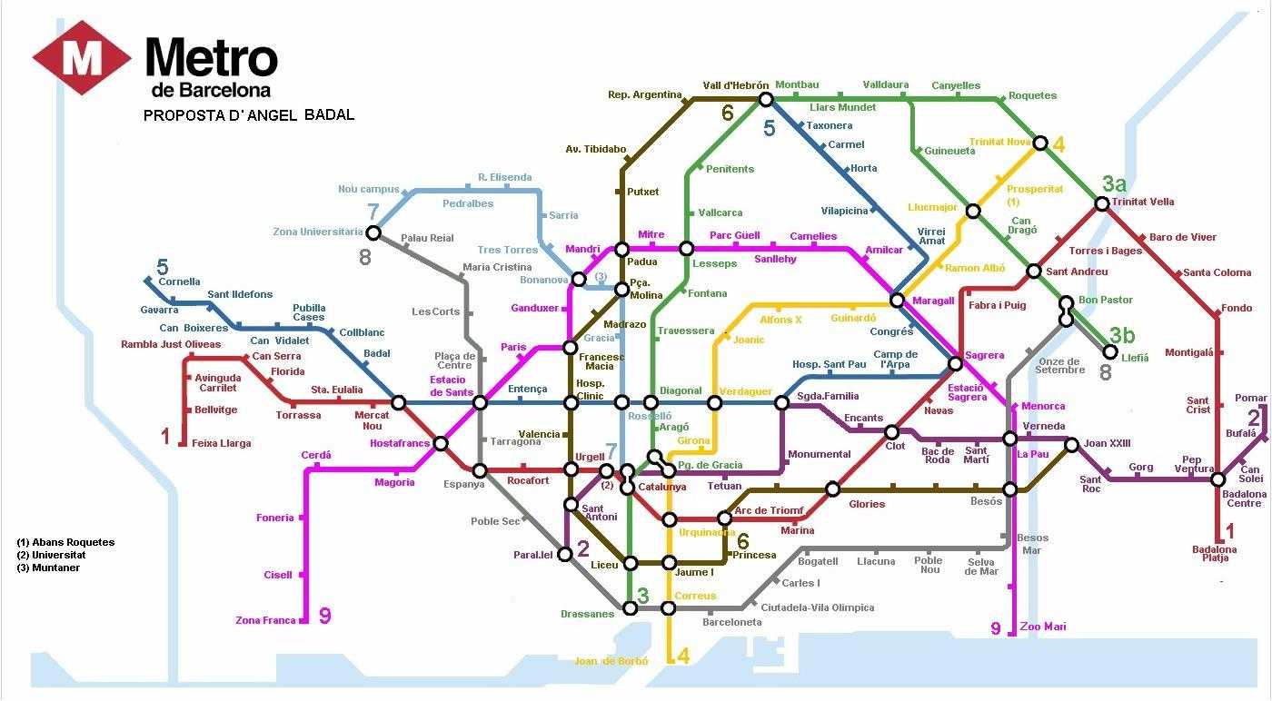
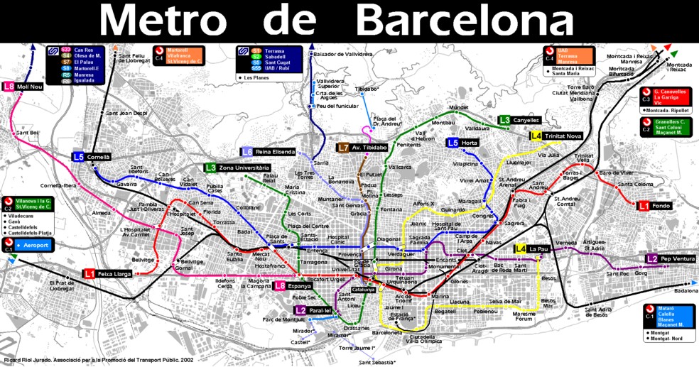
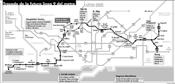
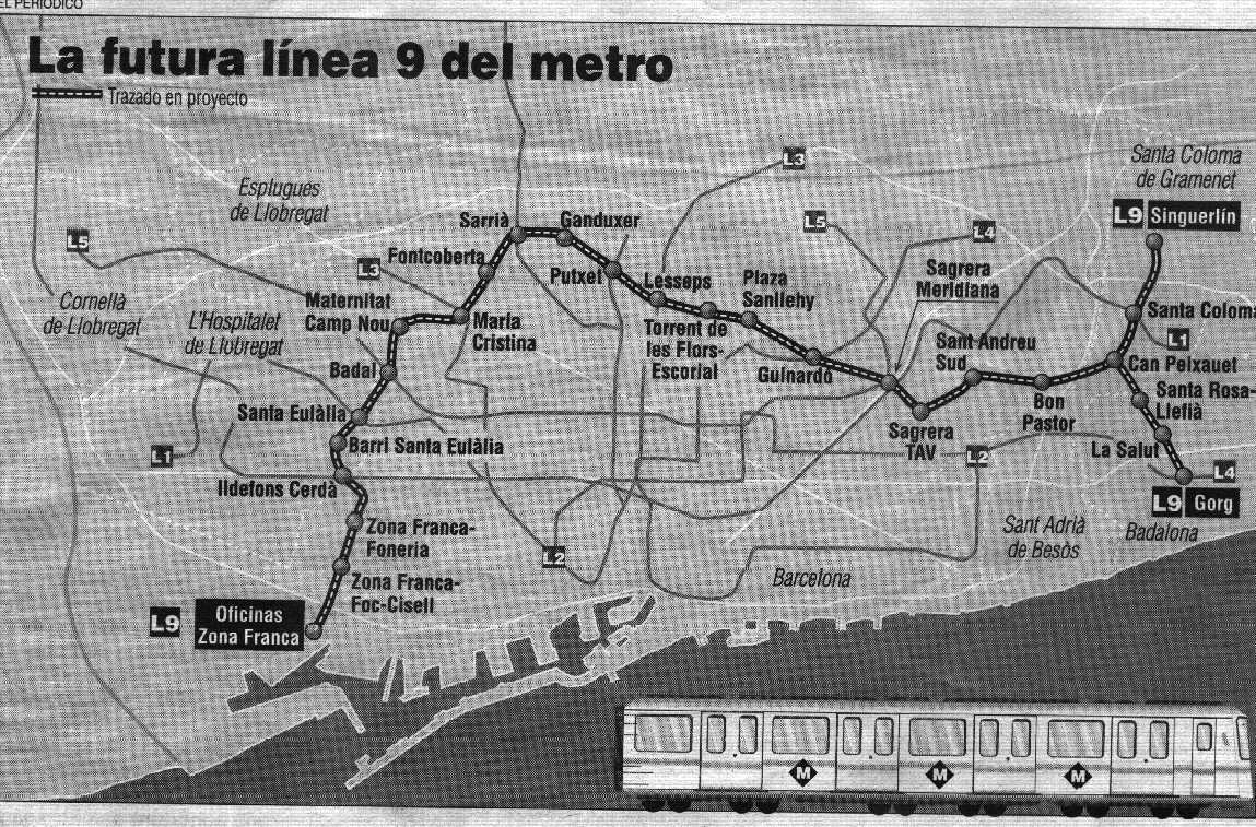
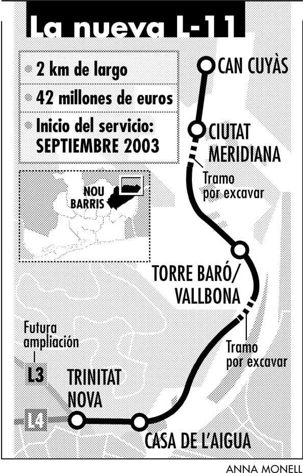
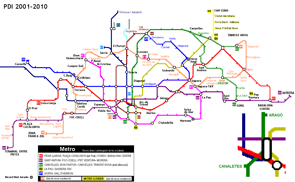
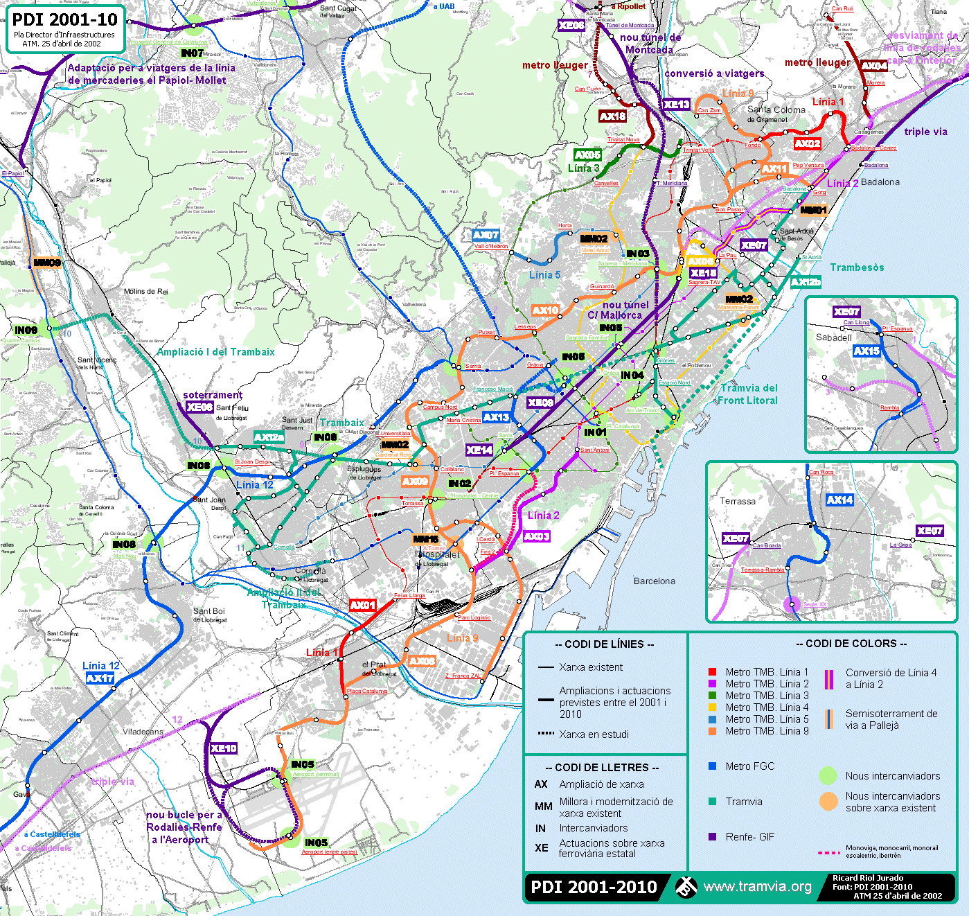
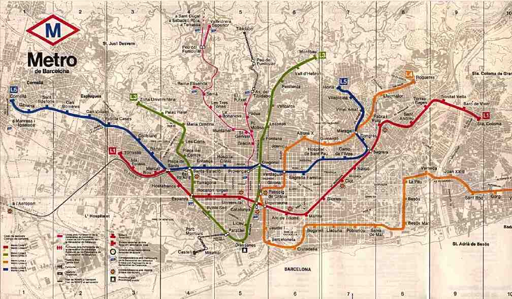
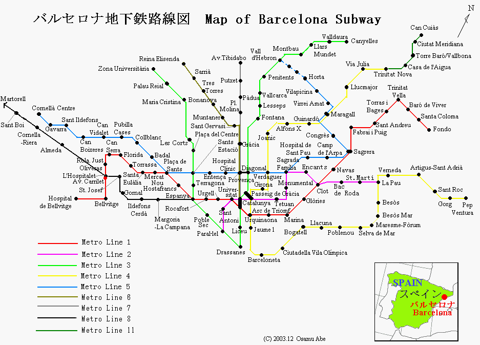
Barcelona (official Transports Metropolitans de Barcelona Metro; thanks to Michael G. Pellot) Barcelona; select Plànol de la xarxa under Viatjar amb FGC (official Ferrocarrils de la Generalitat de Catalunya, with light rail connections. Barcelona (Robert Schwandl original; UrbanRail.Net) [6.10] Barcelona as of April 2010 (new contribution of Angel Badal; described as the new program 2009-2018) [6.10] Barcelona (map produced and provided by Angel Badal) Barcelona as of January 2003 (thanks to Angel Badal) Barcelona Line 9 approved 15 June 2000 (pdf download only; thanks to Angel Badal) Barcelona Line 9 map (thanks to Angel Badal) Barcelona anticipated line 9 dark and light (thanks to Angel Badal) Barcelona Line 11 (thanks to Angel Badal) Barcelona metro development map 2001-2010 (thanks to Angel Badal) Barcelona a second metro development map 2001-2010 (thanks to Angel Badal) Barcelona a third metro development map 2001-2010 (thanks to Angel Badal) Barcelona updated: anticipated 2010; pdf download only (thanks to Angel Badal) Barcelona (low quality scanned image, ca. 1980) Barcelona (scanned image from the David Williams collection) Barcelona (map by Osamu Abe 2003.12)
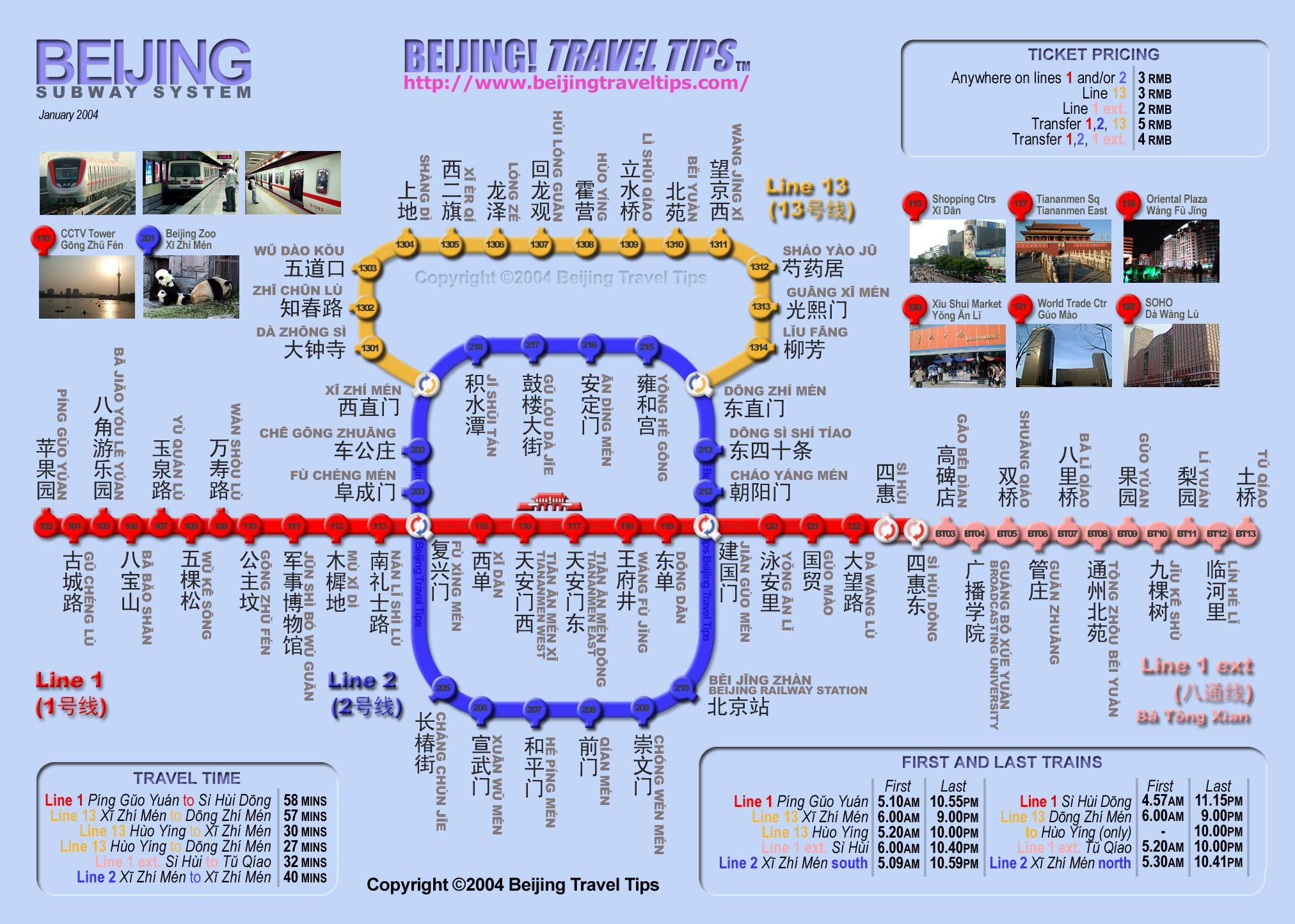
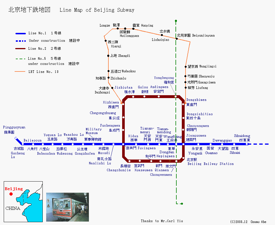
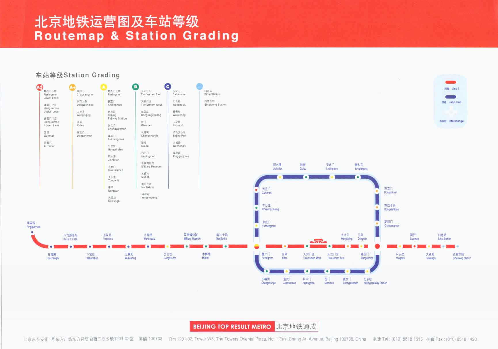
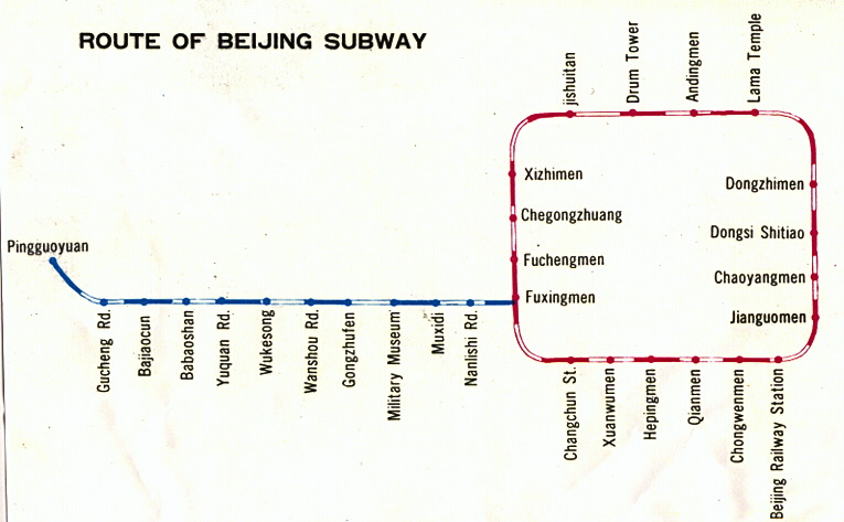
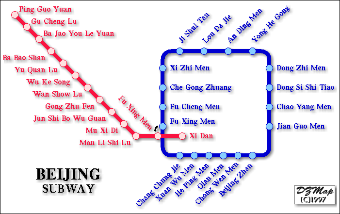
Beijing (official Beijing Subway; thanks to Patrick Leung [9.05]; update [11.09]) Beijing (Beijing Travel Tips) Beijing (Robert Schwandl original; UrbanRail.Net) Beijing (archival; map by Osamu Abe 2003.12) Beijing (JohoMaps; thanks to Jonathan Ho) Beijing (archival; gift of Mark Ovenden) Beijing (archival; Paul Waby "Westinghouse signals" unofficial map) Beijing (archival; map thanks to Allen T. Zagel; see "scanned" or "images" section for photos) Beijing (archival; map by Dmitry Zinoviev 1997; used by permission)
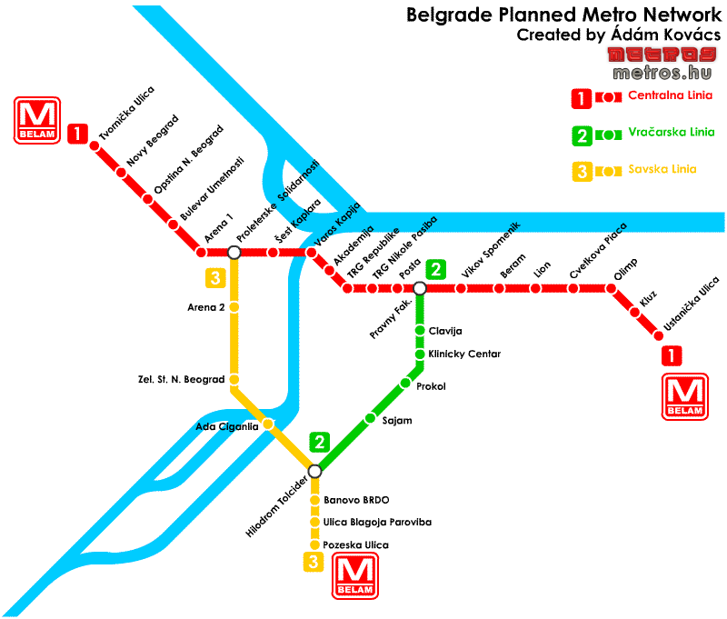
Belgrade (Official Beovoz; thanks to Milos Glisic, who advises in part "There are three underground stations in the downtown core. They are Centre Station (Centar), Karadjordjev Park and Vuk's Monument (Vukov Spomenik).") Belgrade (original map by Kovács Ádám; 12/05)
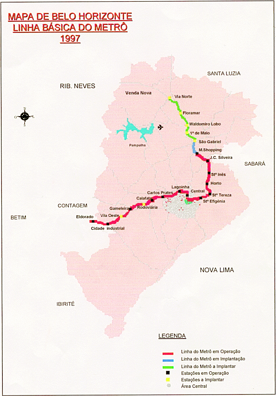
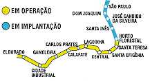
Belo Horizonte (official CBTU Metrô de Belo Horizonte) Belo Horizonte (map thanks to Osiel Bonfim) Belo Horizonte (map by Osamu Abe 2004.12) Belo Horizonte (local download; thanks to Dmitry Zinoviev)
Berlin interactive network map (official Berlin Verkehrsbetriebe; thanks to Sebastian Weber [11.09]) Berlin interactive city map (official Berlin Verkehrsbetriebe) Berlin (scanned official August 2009; gift of John Urang [11.09]) Berlin (Robert Schwandl original; UrbanRail.Net) Photographs of all the Berlin U- and S-Bahn stations can be found in two recent publications by metroPlanet Press: Berlin U-Bahn Album and Berlin S-Bahn Album, both by Robert Schwandl Berlin (also paris, Hamburg, Bochum, and Müaut;nchen) station photos QTVR/123d (thanks to Jean Gefroi) Berlin historical 1931-1994 (the formerly-presented 100 year history has been discontinued; thanks to Markus Jurziczek for the original and for information) Berlin (October 13, 2002; official S-Bahn Berlin GmbH; thanks to Sebastian Weber for original information and recent update; thanks to H. Resa for update; thanks to Jan Krapka for current update) Berlin (map by Osamu Abe 2000.11)
Bielefeld (scroll to bottom of page) (official moBiel) Bielefeld (map by Osamu Abe 2001.3)
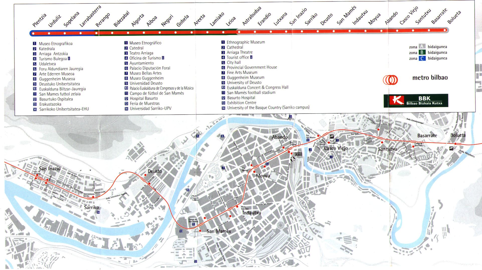
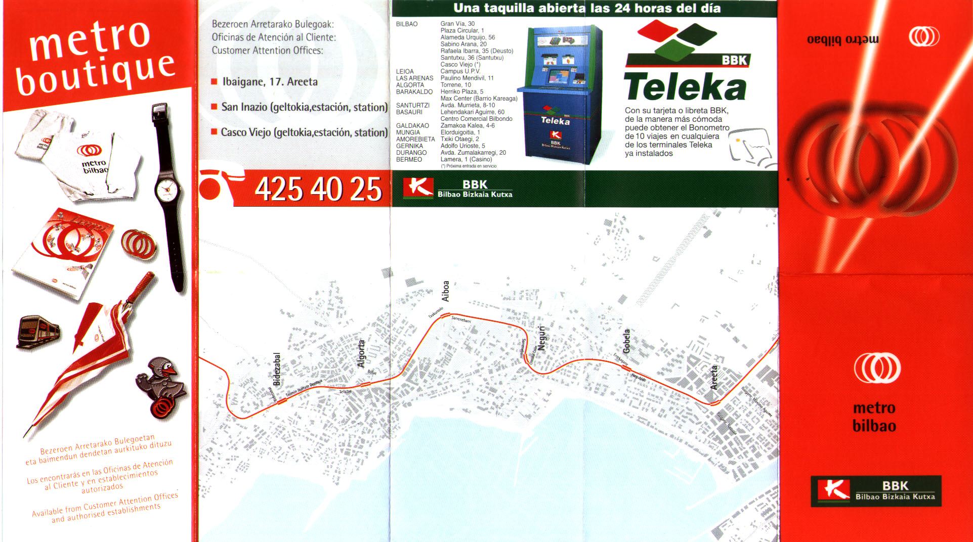
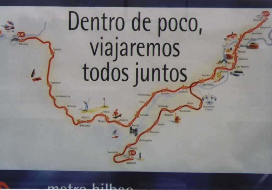
Bilbao (official Metro Bilbao) Bilbao (scan May 1999 from personal collection; reverse). Bilbao (photograph of Bilbao Metro poster; with planned extension; see official map above for station names) Bilbao (Robert Schwandl original; UrbanRail.Net) Bilbao (map by Osamu Abe 2002.02)
Bochum (Robert Schwandl original; UrbanRail.Net)
Bonn (Osamu Abe 2004.02; archival) Bonn (Bonn Stadtbahn system is a subsidiary of the Köln system; Robert Schwandl original; UrbanRail.net [4.9.09])
Boston (official Massachusetts Bay Transportation Authority; thanks to Mike Sullivan for link update) Boston ("This is a professional strength layered GIS map - a rarity to get so much detail!" -- Bryce Nesbitt) Boston (map by Osamu Abe 2004.05) Boston (Hostelling International Boston)
Brasília (official Metro DF) Brasília (scan of official pocket guide; thanks to Frank for the gift of a guide) Brasília (map by Osamu Abe 2004.11) Brasília (Robert Schwandl original; UrbanRail.Net) Brasília (listed as "pre-operation" by Allen Morrison; thanks to Dan Weissmann for update information) Brasília (map thanks to Osiel Bonfim)
Bratislava (planned) (original map by Kovács Ádám; updated 12/05)
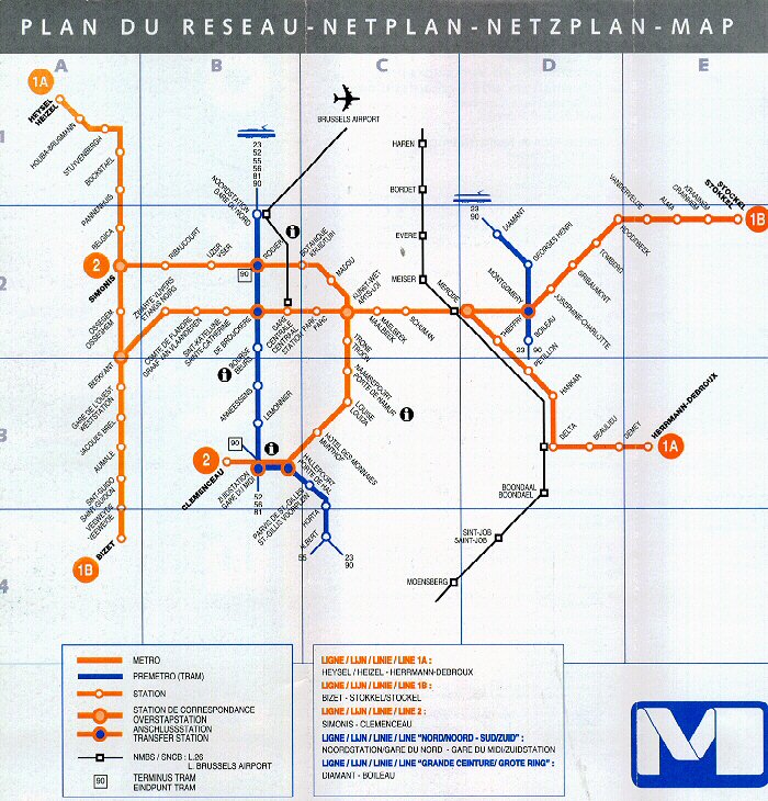
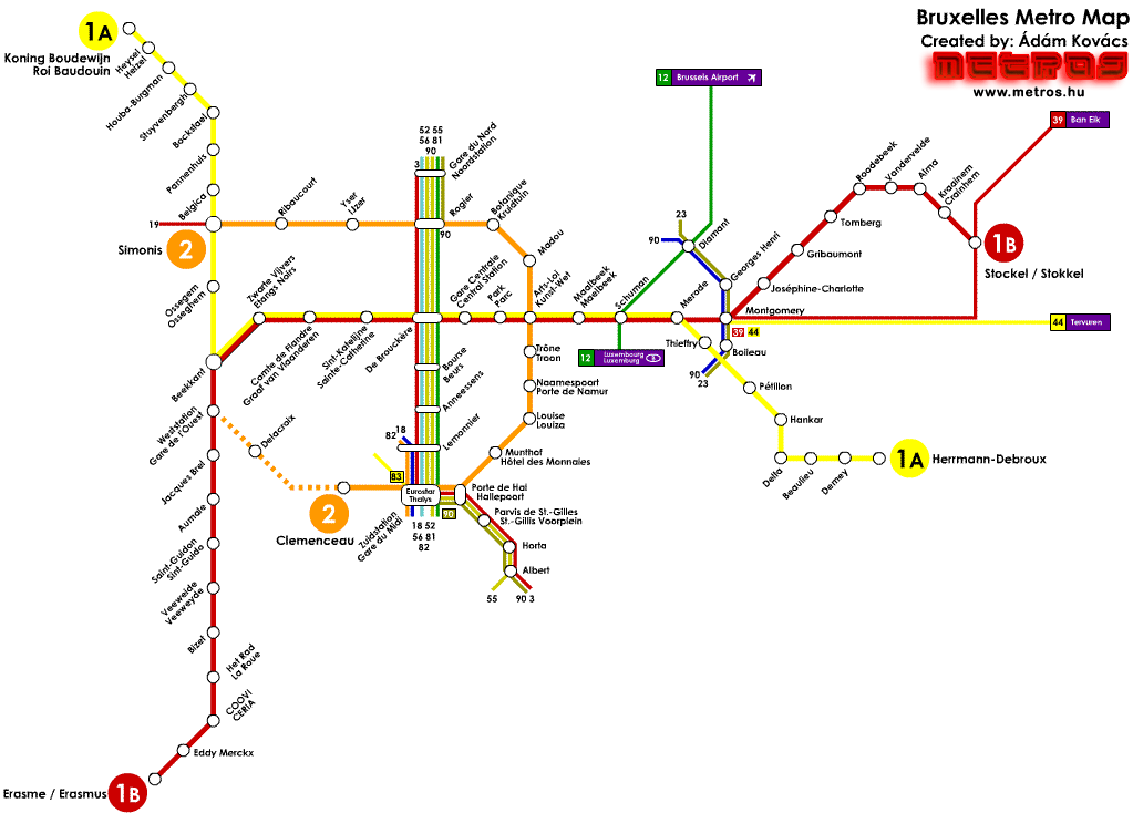
Brussels link to secondary pages not allowed (official S.T.I.B.-M.I.V.B. [Société des Transports Intercommunaux de Bruxelles - Maatschappij voor het Intercommunaal Vervoer te Brussel; thanks to Pierre Berquin) Brussels (Pierre Berquin's Planitram) Brussels (Yves Fourneau's impressive collection of map links) Brussels (American College of Louvain) Brussels (scan of official; thanks to Ron Carson) Brussels (Robert Schwandl original; UrbanRail.Net) Brussels (map by Osamu Abe 2004.05) Brussels ((original map by Kovács Ádám; updated 12/05)
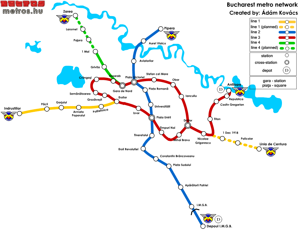
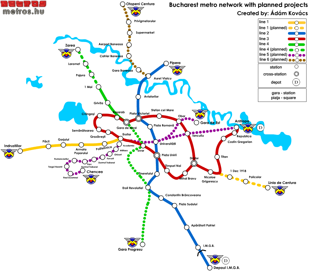
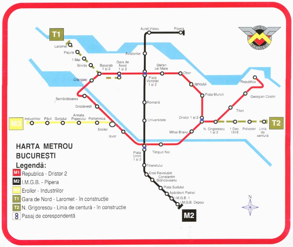
Bucharest (official METROREX; under reconstruction 12/05) Bucharest (Romania official travel and tourist information [06/06]) Bucharest (original map by Kovács Ádám; current projects included; updated 12/05) Bucharest (original map by Kovács Ádám; planned projects included; updated 12/05) Bucharest (map by Osamu Abe 2000.10) Bucharest (Robert Schwandl) Bucharest (gift of Mark Ovenden; 1996 archive)
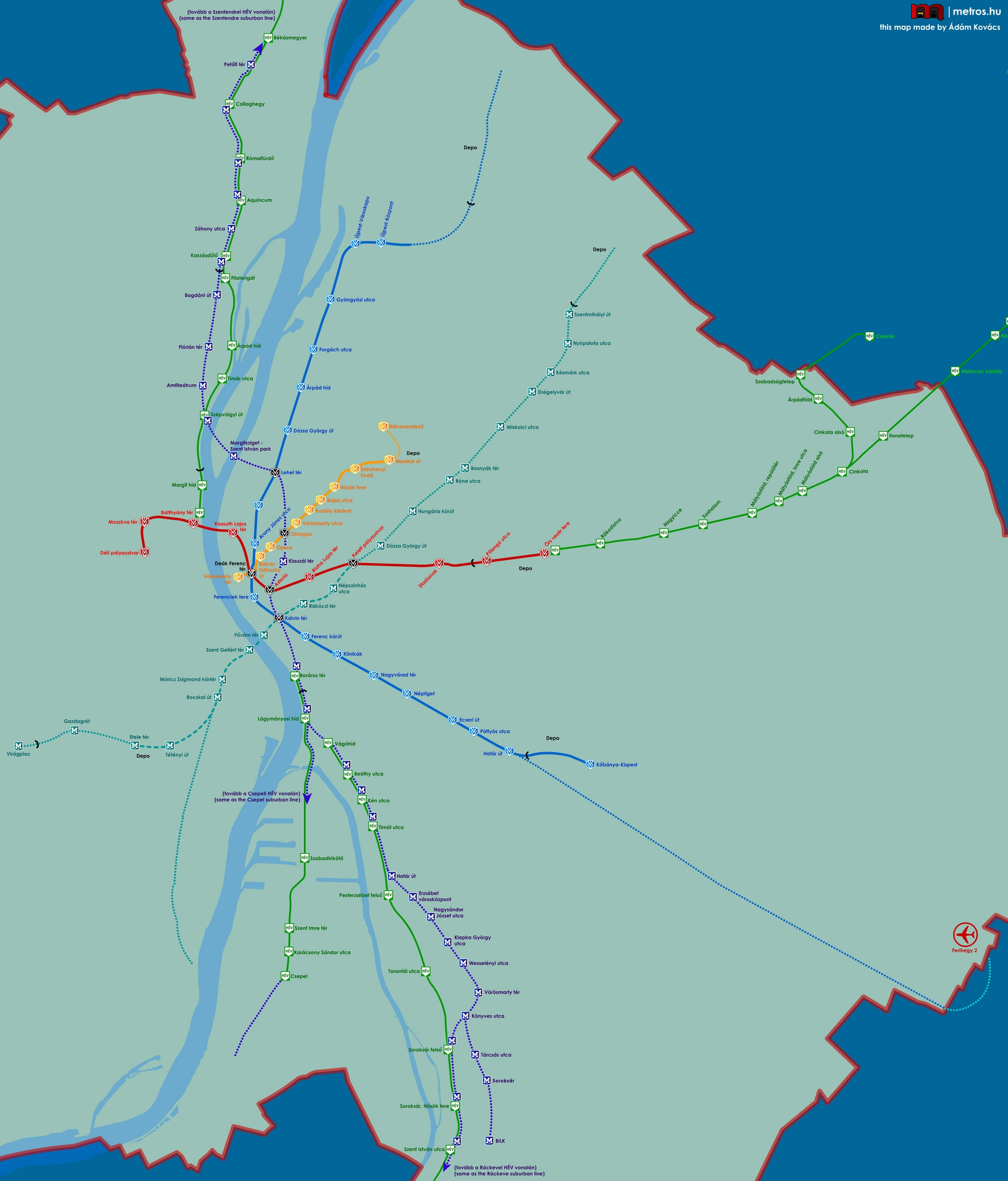
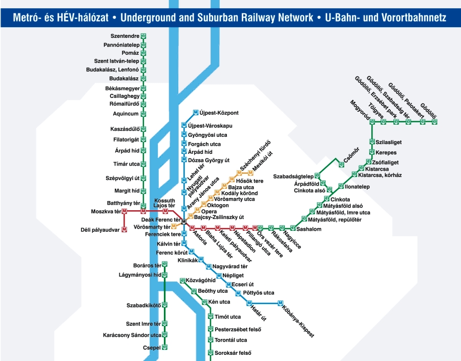
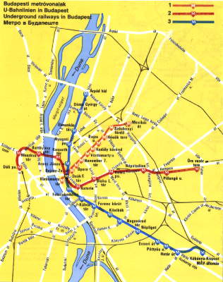
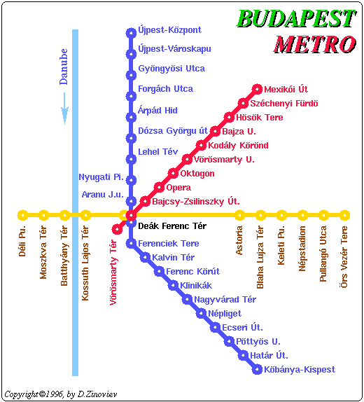
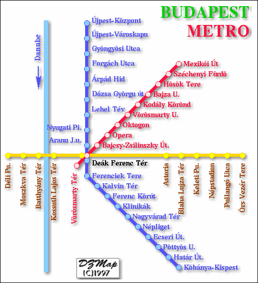
Budapest (official BKV system page; map loads on first trial, but cache gets a blank page that must be cleared before reload is possible (English version evident also); a special Metro 4 page is available (thanks to Václav Šípec)) Budapest (original map from the author of the Budapest Metros page: Kovács Ádám; updated 12/05; he also provides a 2005 Budapest metro map containing the BKV logo and his name) Budapest metro 4 and cross-section Budapest (gift of Mark Ovenden; 2001 archive) Budapest (1990, pre-north-south line; Norbert Reulke) Budapest (current; map by Norbert Reulke) Budapest (map by Dmitry Zinoviev 1996; used by permission) Budapest (map by Dmitry Zinoviev 1997; used by permission)Budapest (Robert Schwandl original; UrbanRail.Net) Budapest (map by Osamu Abe 2002.05)
Buenos Aires Underground (official Metrovías S. A., home page; English selector does not [4.9.09] have access to system map. Premetro and Railline Urquiza maps accessible through selection sequence Servicio al Usario and Mapas; thanks to Gabriel Tuesta Antezana; thanks to Ulrike Reichelt-Trinanes for clarifying information [4.9.09]) Buenos Aires (maps thanks to Sr. Angel Badal; connecting tramlines below) Federico Lacroze connection Primera Junta connection (projected; thanks to Juan José Scarano for correction) Constitución-Zoo connection (projected; thanks to Juan José Scarano for correction) Buenos Aires (map by Osamu Abe 2003.08)
Buffalo (official Niagra Frontier Transportation Authority) Buffalo (scanned image from the David Williams collection) Buffalo (Buffalonet; text explains "Just north of the Theater Station, the train heads underground . . .") Buffalo (map by Osamu Abe 2001.03)
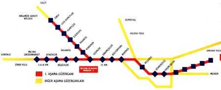
Bursa (official BursaRay) Bursa (official BursaRay archival; marginal legibility) Bursa
Owner: Bursa Büyüksehir Belediyesi (Bursa Metropolitan Municipality); archival including details below:
Name: BursaRay
Total length planned: 55 km (will be completed in 4 phases)
Length of first phase: 20.6 km (Metro GrossMarket-Acemler branch: 5.6 km; Emek- East terminus: 15 km)
Underground: 3.7 km, the rest on the surface.
Number of stations: 23 (3 underground)
Construction for the first phase will be completed in a period of 900 days
Cost: 457.501.979 DM+35.000.000 USD (1st phase)
Construction consortium: Siemens, Güris, Tüvasas, Simko
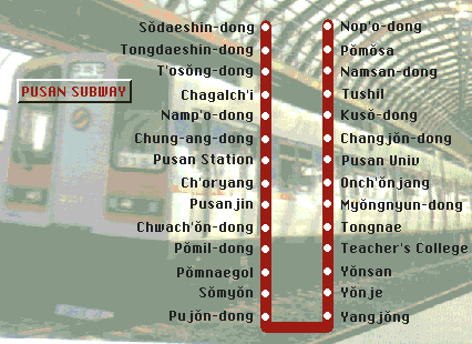
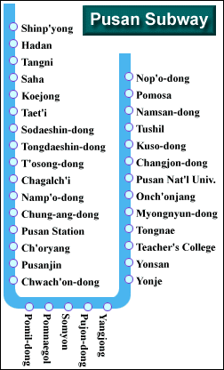
Busan (Pusan) (official Busan Transportation Corporation; "English" link inoperative as of [5/07]; thanks to David David) Busan (source misplaced) Busan (source misplaced) Busan Busan (map by Osamu Abe 2003.12)
[A], [B], [D], [E], [F], [G], [H], [I], [K], [L], [M], [N], [O], [P], [R], [S], [T], [U], [V], [W], [Y], [Z]
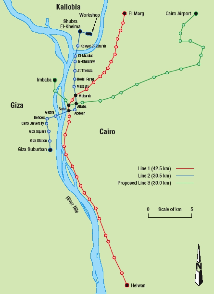
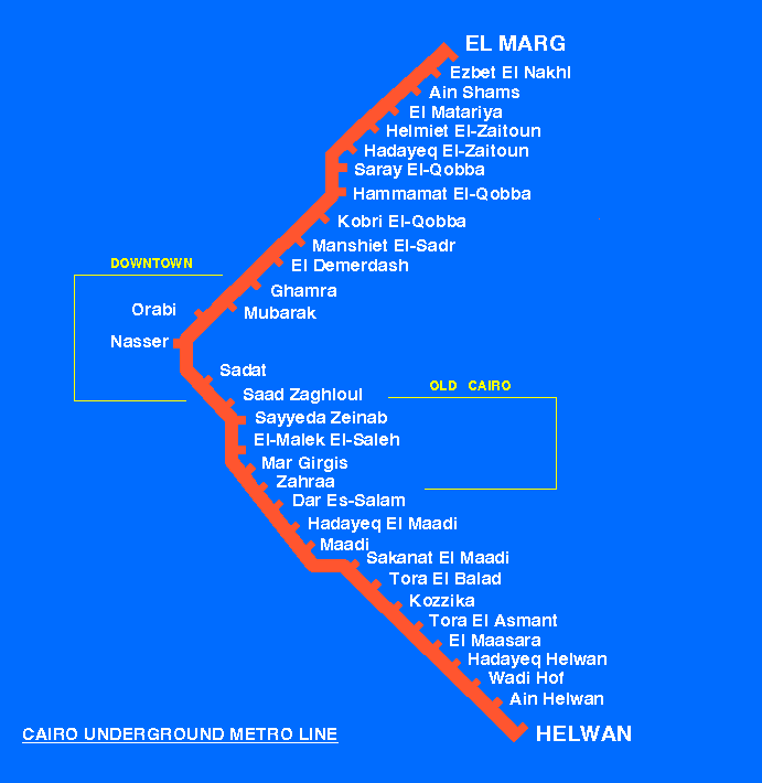
Cairo (Civil Engineering magazine 1999, 132, May/August, 104) Cairo (A-1 Hotels; archival) Cairo (Rail 1435) Cairo (archival) Cairo (map by Osamu Abe 2002.08)
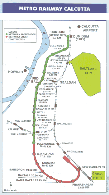
Kolkata (Calcutta) (official Metro Railway Caclutta; select "Our Railway Map" and click to obtain enlarged scrollable map) Calcutta (Kolkata) (gift of Mark Ovenden) Calcutta (Kolkata) (proposed extension, The Telegraph, Calcutta, February 4, 2005) Calcutta (Kolkata) (map by Osamu Abe 2003.12) Calcutta (Kolkata) (clickable map provided by Timir Kanti Ganguly; metro stations are shown by dark squares, but lines themselves are not shown)
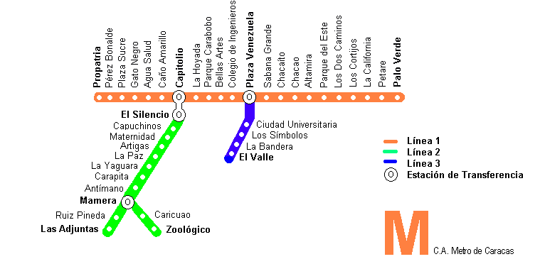
Caracas; choose "Red Metro - Metrobús" (official C. A. Metro de Caracas; thanks to Gabriel Tuesta Antezana) Caracas (Venezuela Virtual) Caracas (Max Hovens' Rail 1435) Caracas (map thanks to Miguel Angel Montaño Gutièrrez) Caracas (map by Osamu Abe 2004.05)
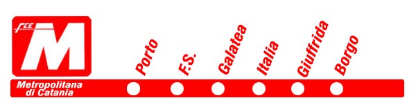
Catania; choose English/Company (Azienda)/Map (Mappa) (official Ferrovia Circumetnea; thanks to Andrea Tartaglia) Catania (no map); Metropolitana di Catania page of Andrea Tartaglia. Catania ("a rather rare version" thanks to Mark Ovenden, author of "Metro Maps of the World") Catania (Robert Schwandl original; UrbanRail.Net) Catania (map by Osamu Abe 2001.04)
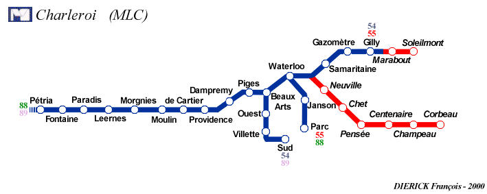
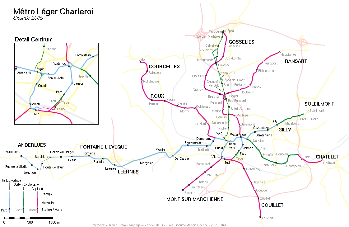
Charleroi Light Metro map created and provided by François Dierick; see also the map from Dierick's MLC Charleroi Light Metro page Charlerois (Métro Léger Charleroi map by Tijmen Stam, who generously provided a copy) Charleroi (map by Osamu Abe 2001.03)
Chelyabinsk (from encyclopedia "Chelyabinsk" (2001); thanks to Alexander I. Sapozhnikov for citation information; see also Chelyabinsk Metropolitan; thanks to Robert Schwandl) Chelyabinsk (gift of Mark Ovenden) Chelyabinsk (Robert Schwandl original; UrbanRail.Net)
Chicago (official Chicago Transit Authority with clickable system maps; original thanks to Marcy Huttas) Chicago (map by Osamu Abe 2000.04)
Cincinnati (abandoned, never used; thanks to Jake Mecklenborg for original notice and to David Forgue for link update; thanks to Mike Taylor for spelling correction for the city name!)
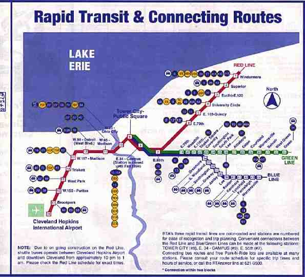
Cleveland (official RTA Greater Cleveland Rerional Transit Authority; thanks to Mike Cermak for update 02/06; maps and schedules are available for all lines [earlier: thanks to Frank Gerlak; thanks to Paul Samuels for map update information; thanks to Sean Mate for further update information]) Cleveland (scanned image from the David Williams collection) Cleveland (map by Osamu Abe 2004.05)
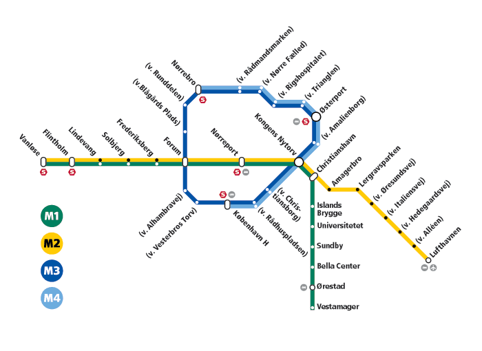
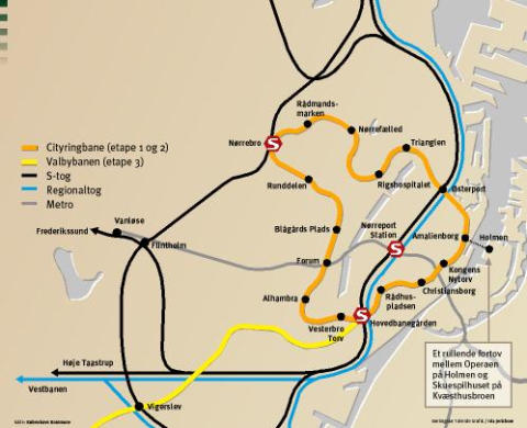
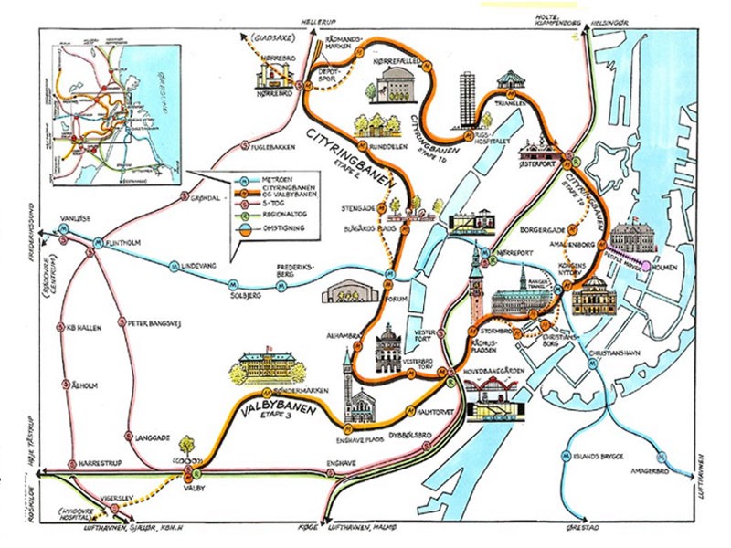
Copenhagen (official Metro page; also available in English; thanks to Rasmus S. Olsen, who advises that (a) on May 26, 2003, a national holiday, both of the initial two lines (M1 Nørreport-Vestamager and M2 Nørreport-Lergravsparken) will be extended from Nørreport to Frederiksberg, and in December 2003 from Frederiksberg to Vanløe and (b) in 2007, M2 will be extended from Lergravsparken to Lufthavnen (Copenhagen Airport), with (c) talk of possible cityring lines M3 and M4 in 2010)) Copenhagen (bottom of page; Martijn Koch's "Wanda Wanders Happy Metro Map" - thanks to Martijn Koch [1/07]) Copenhagen (archival map as of 2002.01; thanks to Rasmus S. Olsen) Copenhagen archival construction photos courtesy of Rikke Faaborg) Copenhagen (and cityring plans; thanks to Rasmus S. Olsen) Copenhagen (Robert Schwandl original; UrbanRail.Net)
[A], [B], [C], [E], [F], [G], [H], [I], [K], [L], [M], [N], [O], [P], [R], [S], [T], [U], [V], [W], [Y], [Z]
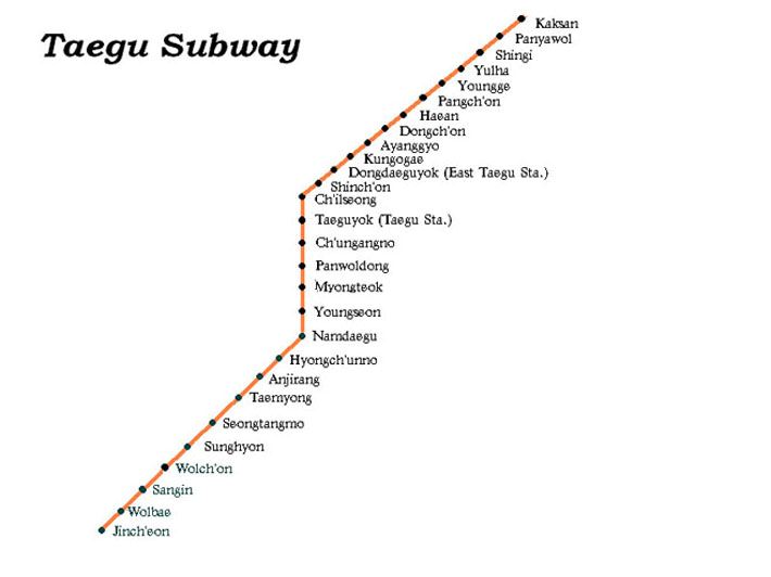
Daegu (select "User's Guide" or "line map" from the menus) (official Daegu Metropolitan Subway Association) Daegu (Robert Schwandl original; UrbanRail.Net) Daegu (map by Osamu Abe 2005.10) Taegu (map created and provided by Dr. Alexei Arkhipov; thanks to Jeff Briere for cluing the clueless that Taegu is an alternate spelling of Daegu)
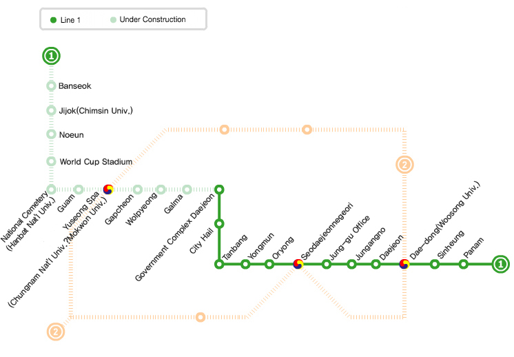
Daejeon; MAP (small) available on this page with English notation "A SUBWAY LINEMAP" does not currently [6/06] produce a larger map (official Daejeon Metropolitan Express Transfer Corporation; thanks to HAN Woojin) Daejeon (larger English version by HAN Woojin, to whom many thanks [1/07]; pale green line is to open May 2007)
Dallas (official DART Dallas Area Rapid Transit; see also the McKinney Avenue Streetcar; thanks to Jim Miller (aka Geezer #1) for a guided tour)
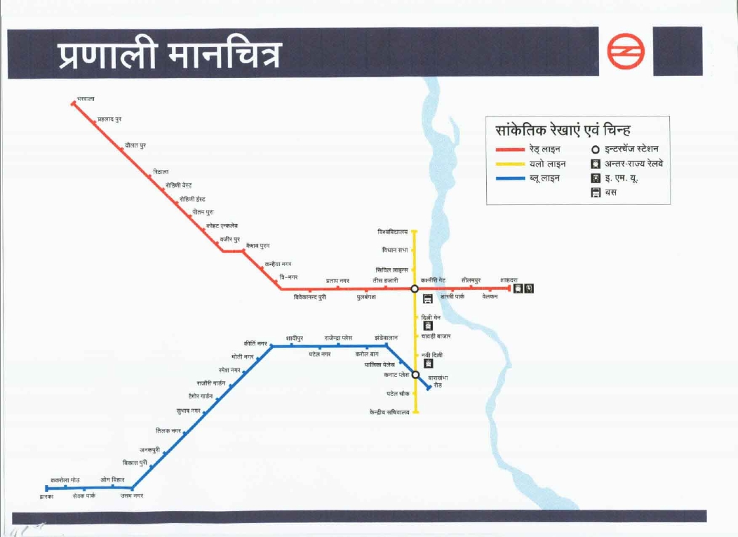
Delhi (official Delhi Metro Rail Corporation; under connstruction; thanks to Perry B. Carter) Delhi (Robert Schwandl original; UrbanRail.Net) Delhi (plans; gift of Mark Ovenden)
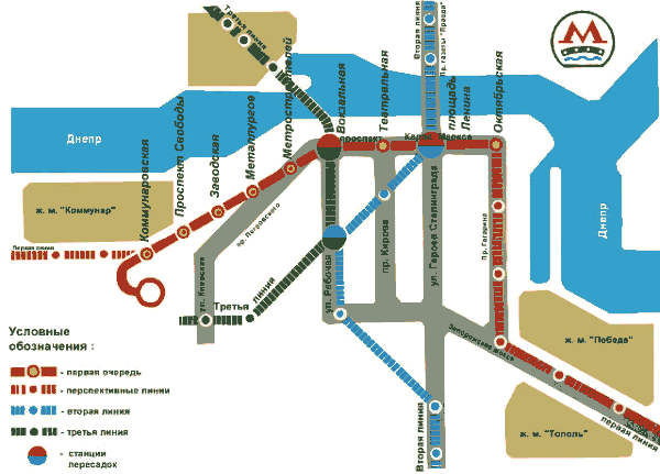
Dnepropetrovsk (Robert Schwandl original; UrbanRail.Net) Dnepropetrovsk (gift of Mark Ovenden) Dnepropetrovsk (map by Osamu Abe 2004.02)
Donetsk (under construction since 1991; Donetsk Metropoliten page and a babelfish translation thanks to Pavel Alekseyev, whose forum page will respond to questions even if in English)
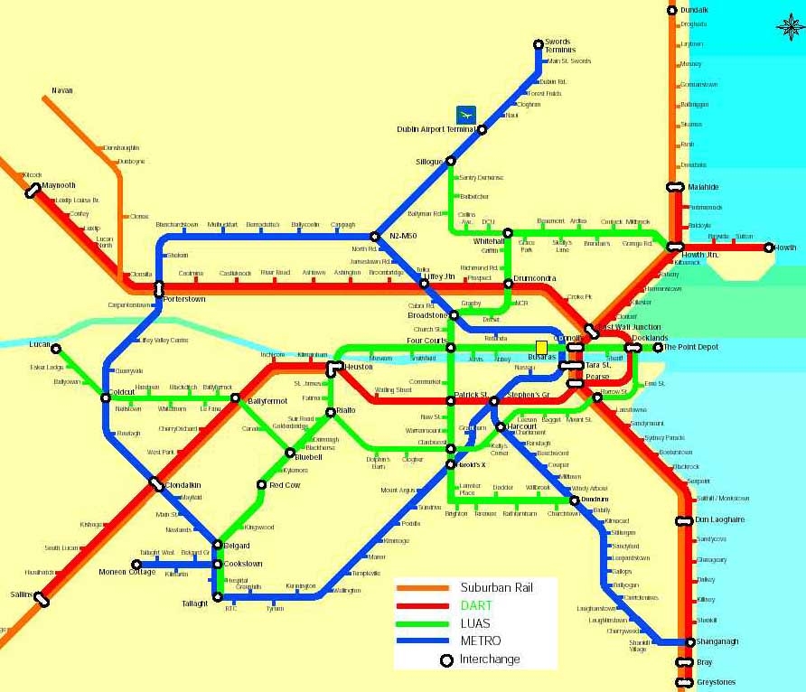
Dublin revised plan for transit and announcement thereof; thanks to Jonathan Dowling for notice (03/06) Archives of earlier plans, now abandoned/revised:
Dublin (gift of Mark Ovenden) Dublin underground and surface light rail (thanks to Matthew Goldman for link update information)
Düsseldorf (select Fahrplan, then Liniennetz; then the city name; official Rheinische Bahngesellschaft AG; thanks to Ron Carson; thanks to "buongiorno" for update information; thanks to René for update valid as of [7/06] and [1/07])
[A], [B], [C], [D], [F], [G], [H], [I], [K], [L], [M], [N], [O], [P], [R], [S], [T], [U], [V], [W], [Y], [Z]
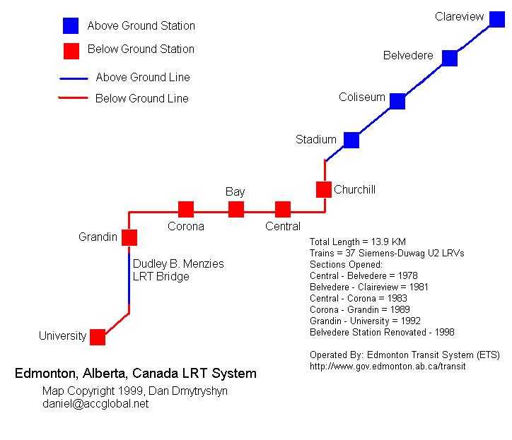
Edmonton (official Edmonton Transit System; day map only -- follow links from official page for night service, etc.) Edmonton (map by Dan Dmytryshyn 1999; provided by the maker) Edmonton (map by Osamu Abe 2003.09)
[A], [B], [C], [D], [E], [G], [H], [I], [K], [L], [M], [N], [O], [P], [R], [aaaa
Posted via email from projectbrainsaver